Route map

I started from the Clesketts car park which is near Hallbankgate in north east Cumbria. It was a bit cloudy and blustery but there were some good views to be had. I walked up by Tortie Hill and I got a cheery wave and good morning from a man who lived in the house below the hill.
Simmerson Hill, Talking Fell and Whinny Fell from Clesketts

Bleddy Bullocks

Approaching Howgill I saw cattle ahead. I wasn't going to turn around this time. As I got close I noticed they didn't have any udders so they were male cows. The one on the left of the path saw me coming and moved to the right of the path to be with his mates. I said "hello coos" and they looked at me slightly curiously. The last bullock was startled when it heard me and it looked like it might kick off but I said "sorry coo" and he was quite happy with the apology and ate some more grass. If only all cattle were like this, I heard a woman got trampled by cattle in Halifax a couple of days before on Tuesday.
Tortie Hill

Looking back at Howgill

I'd turned left at Howgill making my way by Stagsike, the RSPB building. The RSPB have named this the Geltsdale Nature Reserve but I have a few issues with this because Geltsdale is on the other side of Cold Fell! This area is Tindale, surely?

Maybe the locals here call it Geltsdale?
Seat with Geltsdale written on it

In my mind it should have Tindale on it

Passing Stagsike on the way to Tindale Tarn

Looking back at Stagsike and Tortie Hill

Rush hour on this ROW

I wasn't going that way though I was still heading eastward.
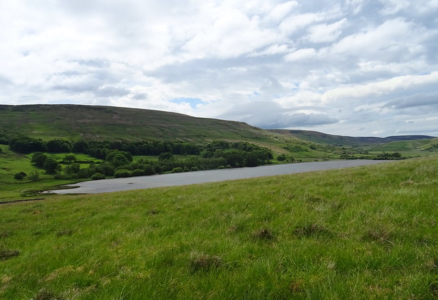
Tindale Tarn now in view

Looking back to Tindale Tarn and Tortie Hill

Very cute lamb

It didn't move an inch as I went by it!
Lunch time quarry

I had my lunch here trying to get out of the wind. It was swirling about though so I didn't stay that long.
Looking back on the disused railway track near Tindale

Stephenson's rocket used to haul loads up and down here to Hallbankgate and Brampton
On the way up Tarnhouse Rigg

From Tindale I'd took the ROW left. I should have ignored the direction arrow because this led to no man's land and rough grass. I should have followed the track to the left which I eventually joined and followed to a gate.
Quarry near Tindale

My lunchtime quarry was on the right in this shot.
Tindale Tarn with Cold Fell above it
I had thought about doing this fell but it was too windy today to be at that height, 621m
Brown Fell, Simmerson Hill, Talking Fell and Tortie Hill in view

Stagsike and Howgill below Cold Fell and Brown Fell

No more photos were taken as I rounded Tortie Hill and back to the car park. A smashing walk. 5.5 miles with 100m ascent, Clesketts - Howgill - Stagsike - Tindale - Thorn - Clesketts.


