I put up with all this for a long time because I struggled to justify getting an expensive dedicated GPS unit. But I eventually gave in and bought a Satmap Active 20 with full GB 1:25k maps. It was the best thing I could have done because it revolutionised my walking!
The battery life is good enough for a full day; I can zoom in very close or to any degree I choose; it's completely waterproof although I can use the buttons if rain affects the touchscreen; the positioning accuracy is extremely good, and the unit is incredibly tough. There are lots more advantages over a phone, but that will do for now!
One last thing... I can't get to grips with Satmap's Explorer, but I'm a huge fan of OS Maps. 
I can only agree 100% about the SatMap - 'its a perfect tool'.
I have the SatMap 10 (not touch screen) and full UK OS mapping at scales of 1:50,000, 1:25,000 & 1:10,000 and you can zoom in even tighter.
It gets down to individual blades of grass levels (well not quite) but with 1mm on the screen being only 10 metres on the ground its pretty close.
Accuracy is normally under 20 feet - and even shows which side of a track you have walked up.
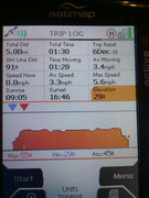
It gives you a good summary of times, distances, height gain etc for post walk evaluation.
Recommended.
I found with the SatMap "Adventure" maps that being based on "Open Cycle Map" & "Open Street Map" are not much use for hiking.
I have been walking on a footpath and all of a sudden it disappears (on the map) and there is no indication of it reappearing, in other cases a path is shown on the map but is not indicated or in existence in 'the real world'. I have given up on them (I have the full UK at 1:25,000 Adventure map) but find the OS mapping to be accurate.