Having studied Lostways for a few years now, using the analogy of a the course of a river is a line of thought that has helped me to recognize
Strength of Way. Surely a footbridge over an unfordable river with road bridges about a mile upstream and down stream took some motivation to build.
The Right of Way leading directly to the bridge on the East bank, combine 3 sources of foot traffic, so how much pedestrian traffic are these ways directing towards the west? That is the direction of the County Town, Shrewsbury.
Two Villages or hamlets connect from East; Walton and High Ercall and as far as the Ordnance Survey map indicates, that is it. But an Airfield was built in WW2 to the east and before that was built there are footpaths that indicate footfall from much further away.
airfield_lostways by
Barewirewalker, on Flickr
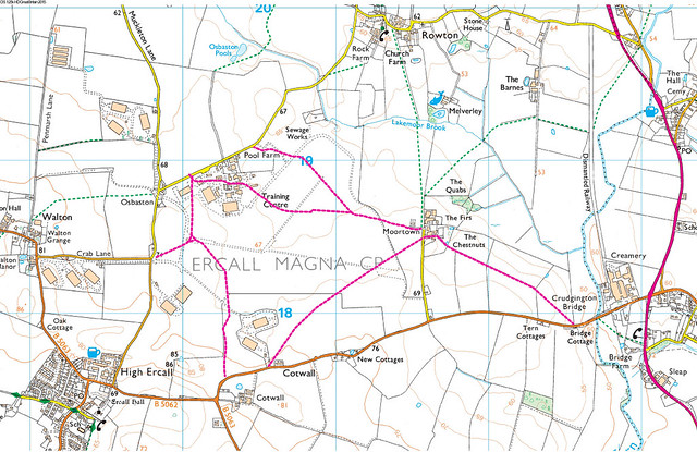
I have overlaid these old ways onto a copy of the OS Explorer map as they were on the prewar map (in red). Also there is an other
old footpath from the Chestnuts to Crudgington Bridge shown. All the lostways due to airfield seem to add continuity of way to those paths that made it onto the Definitive Map and that continuity of way can be seen as possible, by using the hardway provided by the remains from the airfield.
I have walked it, it is a place with an unusual presence, the area is so suited to being an airfield that, when you are in the middle, you almost expect a B17 Flying Fortress to popup on the Horizon. It is a plateau, the sky seems start as the weed strewn tarmac merges with it.
I spoke to the Farmer at the Chestnuts, we found a family connection, he had mostly retired and described the old way down to the bridge at Crudgington as a shortcut to the Rail Station that was on the dismantled railway line. I think a rather defensive description in line with the landowner/Farmer editorial in relation to countryside access, The Chestnut and The Firs would have been two farm holdings and they would have taken milk to the station therefore the footfall to this path station would have come from further a field.
It is worth looking at the Continuity of Way offered by the Righteous Way going north east from here. Mrs BWW and I walked some years ago, some delightful walking along side the River Meese, one of those footpaths often unrecognised for it's quality of way by hill walkers because it is below the horizon. They come as a surprise to those walking in supposed flat land, when you suddenly find yourself down below the ground around.


